
Exploring Society: India and Beyond 1. Locating Places on the Earth

TEXTUAL QUESTIONS AND ANSWERS
1. Returning to page 10 and to Fig. 5.2 in Chapter 5 of this textbook, taking the scale to be 2.5 cm = 500 km, calculate the real distance from the estuary of the Narmada River to the estuary of the Ganga river.
(Hint: round off your measurement on the map to an easy number.)
Ans: Scale: 2.5 cm = 500 km
Actual distance: 1,315 km
To find the equivalent map distance, we can set up a proportion:
2.5 cm / 500 km = x cm / 1,315 km
Cross-multiply and solve for x:
x = (2.5 cm × 1,315 km) / 500 km
x ≈ 6.57 cm
So, the map distance between the estuaries of the Narmada and Ganga rivers should be approximately 6.57 cm, using the given scale.
2. Why is it 5:30 pm in India when it is 12 pm or noon in London?
Ans. The time difference between India and London is primarily due to their locations in different time zones and the way time zones are defined globally.
Time Zones:
- London: Located in the Greenwich Mean Time (GMT) zone during standard time. During daylight saving time, London is in the British Summer Time (BST) zone, which is GMT+1.
- India: Located in the Indian Standard Time (IST) zone, which is GMT+5:30.
Time Difference:
- India is 5 hours and 30 minutes ahead of GMT. This is why, when it is 12:00 pm (noon) in London (GMT), it is 5:30 pm in India (IST). The reason why it is 5:30 pm in India when it is 12:00 pm in London is because India is located in a time zone that is 5 hours and 30 minutes ahead of GMT, which is the time zone London follows during standard time.
3. Why do we need symbols and colors in the map?
Ans: Symbols and colors on maps serve several purposes:
1. Visual representation: Symbols and colors help to visually represent different features, making the map easier to read and understand.
2. Categorization: They group similar features together, such as rivers, roads, or cities.
3. Distinction: Symbols and colors distinguish between different types of features, reducing confusion.
4. Quick reference: They provide a quick way to identify features without needing to read labels or descriptions.
5. Enhance comprehension: Symbols and colors enhance map comprehension, making it easier to analyze and interpret spatial information. In short, symbols and colors on maps simplify complex information, facilitate understanding, and enable efficient communication of geographical data.
4. Find out what you have in the eight directions from your home or school.
Ans: You may note the name of places, buildings, roads, and any other notable places.
5. What is the difference between local time and standard time? Discuss it in groups, with each group writing an answer in 100 to 150 words. Compare the answers.
Ans: Local Time:
1.Refers to the time based on the position of the sun at a particular location.
2.It varies from place to place, depending on longitude. For example, when the sun is at its highest point in the sky, it is noon at that location.
3.Every place on Earth theoretically has its own local time, which can differ even within the same time zone.
Standard Time:
1.This is the time established by law or general usage for a particular region or country.
2.It is based on a specific meridian (usually a whole number of hours offset from GMT/UTC) and applies uniformly across a time zone, regardless of local variations in solar time.
3.This system was adopted to avoid confusion and make communication, travel, and business more efficient. For example, all of India follows Indian Standard Time (IST), which is UTC+5:30, rather than each city having its own local time.
6. Delhi’s and Bengaluru’s latitudes are 29°N and 13°N; their longitudes are almost the same, 77°E. How much will be the difference in local time between the two cities?
Ans: 1.Since Delhi and Bengaluru have almost the same longitude (77°E), their local times are nearly identical, as local time differences are primarily influenced by differences in longitude, not latitude.
2.Local time changes by approximately 4 minutes for every degree of longitude. However, because Delhi and Bengaluru share nearly the same longitude, there is no significant difference in their local times.
3.The difference in local time between Delhi and Bengaluru is negligible, close to zero minutes.
7. Mark the following statements as true or false; explain your answers with a sentence or two.
Ans: Here are the statements marked as true or false, with brief explanations:
1. All parallels of latitude have the same length.
False. Parallels of latitude vary in length. The Equator is the longest, and as you move towards the poles, the length of the parallels decreases, reaching zero at the poles.
2. The length of a meridian of longitude is half of that of the Equator.
False. The length of any meridian of longitude is the same as the length of the Equator. Both are approximately 40,075 kilometers in circumference.
3. The South Pole has a latitude of 90°S.
True. The South Pole is located at the southernmost point of the Earth, which is at 90°S latitude.
4. In Assam, the local time and the IST are identical.
False. Assam is geographically located to the east of the standard meridian for IST (82.5°E). Therefore, the local time in Assam is slightly ahead of IST, though the entire country follows IST for uniformity.
5. Lines separating the time zones are identical with meridians of longitude.
False. While time zones are roughly based on meridians of longitude, the actual lines separating time zones are often adjusted for political and economic reasons, and therefore, they are not always identical with meridians.
6. The Equator is also a parallel of latitude.
True. The Equator is the most significant parallel of latitude, located at 0° latitude, dividing the Earth into the Northern and Southern Hemispheres.
The Big Questions
1. What is a map and how do we use it? What are its main components?
Ans: A map is a visual representation of an area, showing the relationships between different features, such as roads, buildings, and geographical boundaries. Maps help us navigate, understand spatial relationships, and visualize data.
Main components of a map:
There are three important components of Maps — distance, direction and symbols.
We use maps to:
1. Navigate and find locations
2. Understand spatial relationships and patterns
3. Visualize data and trends
4. Plan routes and journeys
5. Identify geographical features and boundaries
Types of maps include:
1. Political maps (showing borders and cities)
2. Physical maps (showing terrain and natural features)
3. Thematic maps (showing specific data, like climate or population)
4. Topographic maps (showing detailed terrain and elevation)
2.What are the coordinates? How can latitude and longitude be used to mark any location on the Earth?
Ans: Coordinates are a set of numbers that pinpoint a specific location on the Earth's surface. Latitude and longitude are the two primary coordinates used to identify any location.
Latitude:
- Measures distance north or south of the Equator (0° latitude)
- Ranges from 0° to 90° North (N) or South (S)
- Imaginary lines that run parallel to the Equator are called parallels
Longitude:
- Measures distance east or west of the Prime Meridian (0° longitude)
- Ranges from 0° to 180° East (E) or West (W)
- Imaginary lines that run from the North Pole to the South Pole are called meridians
Together, latitude and longitude create a grid system that allows us to pinpoint any location on the Earth's surface. By combining the two, we get a unique set of coordinates that identify a specific point.
Example: The coordinates for New York City are approximately 40.7128° N (latitude) and 74.0060° W (longitude).
To mark a location using latitude and longitude:
1. Identify the latitude (north-south position)
2. Identify the longitude (east-west position)
3. Combine the two to create a unique coordinate pair (e.g., 40.7128° N, 74.0060° W)
This system allows us to accurately locate and communicate the position of any point on the Earth's surface.
3.How are local time and standard time related to longitude?
Ans: Local time and standard time are related to longitude in the following ways:
Local Time:
- Determined by the solar time at a specific location
- Varies with longitude, as each degree of longitude represents a 4-minute difference in solar time
- Not uniform across different longitudes, leading to confusion in coordinating clocks
Standard Time:
- Introduced to simplify timekeeping and communication
- Divides the world into 24 time zones, each separated by 1 hour (15° of longitude)
- Based on the mean solar time at a specific meridian (usually a multiple of 15° longitude)
The relationship between longitude and time zones:
- Each time zone represents a 15° range of longitude
- Time zones are identified by their offset from Coordinated Universal Time (UTC)
- Longitudes are used to determine the standard time zone for a region
For example:
- New York City is at approximately 74° W longitude and is in the UTC-5 time zone (Eastern Standard Time)
- Los Angeles is at approximately 118° W longitude and is in the UTC-8 time zone (Pacific Standard Time)
In summary, longitude determines local time, and standard time zones are established to simplify timekeeping across different longitudes.
Additional Questions and Answers
A. Answer the following in short.
1.What is a map?
Ans: a map is a representation, or a drawing, of some area — it may be a small area, a bigger area, or a very large area like India or even the whole world.
2. What are the three types of maps?
Ans: Following are the three types of maps
1. Physical maps
2. Political maps
3. Thematic maps
3. Explain the types of maps.
Ans: Following are the types of maps:
1. Physical maps, which mainly show some natural features such as mountains, oceans and rivers
2. Political maps, which show details of countries or states, boundaries, cities, etc. (for instance, a map of India with all its States, Union Territories and their capitals)
3.Thematic maps, with a specific kind of information
4. What is the globe?
Ans: A globe is a three-dimensional (3D) spherical model of the Earth or other celestial body, such as a planet or moon. It's a scale model that accurately represents the shape, size, and features of the Earth or other body.
5. What is the difference between latitude and longitude?
Ans: Latitude and longitude are both coordinates used to identify locations on the Earth's surface, but they differ in their orientation and measurement:
Latitude:
- Measures distance north or south of the Equator (0° latitude)
- Lines of latitude are parallel to the Equator
- Ranges from 0° to 90° North (N) or South (S)
- Identifies locations in terms of their angular distance from the Equator
Longitude:
- Measures distance east or west of the Prime Meridian (0° longitude)
- Lines of longitude are meridians that converge at the poles
- Ranges from 0° to 180° East (E) or West (W)
- Identifies locations in terms of their angular distance from the Prime Meridian
6. What are the meridians of longitude?
Ans: 1.Meridians of longitude are imaginary lines that run from the North Pole to the South Pole, passing through the Earth's surface.
2.They are all half-circles running from one pole to the other.
3.They are used to measure longitude, which is the distance east or west of the Prime Meridian (0° longitude).
7. What is Prime Meridian?
Ans:The Prime Meridian is the meridian of longitude that passes through the Royal Observatory in Greenwich, London, England. It is designated as 0° longitude and serves as the reference point for measuring longitude (east-west) coordinates.
Here are some key facts about the Prime Meridian:
1. Zero longitude: The Prime Meridian is defined as 0° longitude.
2. Passes through Greenwich: It passes through the Royal Observatory in Greenwich, London.
3. Reference point: It serves as the reference point for measuring longitude.
4. Global standard: It is the global standard for measuring longitude, adopted in 1884.
5. Time zone reference: It is also the reference point for Coordinated Universal Time (UTC) and time zones.
The Prime Meridian:
- Divides the Earth into Eastern and Western hemispheres
- Serves as the origin for measuring longitude
- Is used as a reference point for navigation, mapping, and timekeeping
In 1884, the International Meridian Conference in Washington, D.C. established the Prime Meridian as the global standard for measuring longitude, ensuring consistency and accuracy in navigation and mapping.
8. What is a grid on the globe?
Ans: The parallels of latitude and the meridians of longitude together on the globe as blue lines.All these lines together constitute a grid for the globe; they are also called grid lines.
9. What do you know about hemispheres?
Ans: A hemisphere is half of a sphere, or a three-dimensional shape that is divided into two equal parts. In the context of the Earth, a hemisphere refers to one of the four regions into which the planet is divided:
1. Eastern Hemisphere: The half of the Earth east of the Prime Meridian (0° longitude)
2. Western Hemisphere: The half of the Earth west of the Prime Meridian (0° longitude)
3. Northern Hemisphere: The half of the Earth north of the Equator (0° latitude)
4. Southern Hemisphere: The half of the Earth south of the Equator (0° latitude)

- Continental hemispheres: Divided by continents, like the North American Hemisphere
- Oceanic hemispheres: Divided by oceans, like the Pacific Hemisphere
Hemispheres help us:
- Understand global geography and spatial relationships
- Divide the world into manageable regions for study and navigation
- Identify time zones and coordinate clocks
In summary, hemispheres are half-spheres that help us organize and understand the Earth's surface.
10. What is the International Date Line?
Ans: The International Date Line (IDL) is an imaginary line on the Earth's surface that runs from the North Pole to the South Pole, roughly following the 180° meridian. It passes through the middle of the Pacific Ocean, roughly following the 180° meridian, and serves as the boundary between two consecutive calendar days.
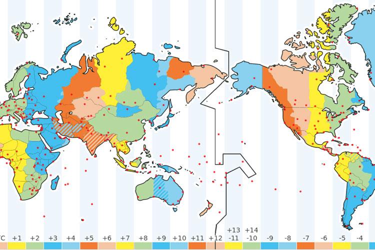
1. Separates two days: The IDL separates two consecutive calendar days, with locations to the west of the line being one day ahead of locations to the east.
2. Runs through the Pacific: The IDL passes through the middle of the Pacific Ocean, roughly following the 180° meridian.
3. Passes through several countries: The IDL passes through several countries, including Kiribati, Samoa, and Tonga.
4. Not a straight line: The IDL is not a straight line, but rather a zigzagging line that avoids dividing some territories and islands.
5. Established in 1884: The IDL was established at the International Meridian Conference in Washington, D.C. in 1884.
The International Date Line has some interesting effects, such as:
- When it's Monday on the west side of the IDL, it's Tuesday on the east side.
- When it's December 31 on the west side, it's January 1 on the east side.
The IDL helps us coordinate clocks and calendars across the globe, ensuring that we're all on the same page (or date).
B. Answer the following in one sentence.
1. What is an atlas?
Ans: An atlas is a book or collection of maps.
2. What are the three important components of maps?
Ans: Distance, direction and symbols are the important components of maps.
3. What are the cardinal directions?
Ans: North, east, south and west are the cardinal directions.
4. What are the ordinal directions?
Ans: The ordinal directions are:
1. Northeast (NE): Halfway between north and east
2. Southeast (SE): Halfway between south and east
3. Southwest (SW): Halfway between south and west
4. Northwest (NW): Halfway between north and west
5. Who has fixed a set of symbols for maps of India (or parts of India)?
Ans: The Survey of India, a government body, has fixed a set of symbols for maps of India (or parts of India).
6. Why do map makers use specific symbols?
Ans: To make maps more easily understood by a variety of users, map makers use specific symbols.
7. Mapping the Earth is a little more difficult because-
Ans: our planet is not a flat surface. It nearly has the shape of a sphere.
8. What is the largest circle on the globe?
Ans: Equator is the largest circle on the globe.
9. Name the reputed center for astronomy over many centuries.
Ans: Ujjayinī (today Ujjain), which was a reputed center for astronomy over many centuries.
10. Who was Varāhamihira?
Ans: Varahamihira was a famous astronomer.
11. Where did Varahamihira live?
Ans: In the city of Ujjayinī (today Ujjain)
12. Which meridian became a reference for calculations in all Indian astronomical texts?
Ans: The Ujjayinī meridian became a reference for calculations in all Indian astronomical texts.
13. What are the ancient Indian cities close to the Ujjayinī meridian?
Ans: Kurukṣhetra, Rohtak, Nagar, Ujjain, Maheshwar and Kanyakumari.
14. What is the geographical expansion of India?
Ans: India’s latitudes extend approximately from to 8°N to 37°N, and longitudes approximately from 68°E to 97°E.
15. How much time Indian Standard Time (IST) is ahead of the local time at Greenwich?
Ans: 5 hours 30 minutes (also noted 5.5 hours).
16. What are the subdisciplines of Social Science?
Ans: Geography, history, political science, economics, sociology, anthropology, archaeology, psychology and a few more.
17. The past is a major source for our identities because-
Ans: It helps us understand who we are and where we come from.
18. In what way is history useful for us?
Ans: It is useful to understand where people, governments or rulers went wrong, and why. Only then can we hope to avoid repeating those errors.
19. Expand the following
IST
GMT
IDL
Ans:
IST- Indian Standard Time
GMT- Greenwich Mean Time
IDL- International Date Line
C. Fill in the blanks:
1. Most maps simply have an arrow marked with the letter ‘N’, which points to the — direction. (south/north)
👁Answer
Correct Answer: North
2. You stand on the Equator and travel towards one of the poles; your distance from the Equator —. (increases/decreases)
👁Answer
Correct Answer: increases
3. Latitudes are expressed in —. (degrees/meters)
👁Answer
Correct Answer: degrees
4. The latitudes of the two poles are 90° North and 90° South respectively; this is noted —. (90°N and 90°S/90°S and 90°N)
👁Answer
Correct Answer: (90°N and 90°S
5. Prime Meridian is marked as — longitude. (0°/10°)
👁Answer
Correct Answer: 0°
6. Latitude and longitude together are the two — of a place. (subordinates/coordinates)
👁Answer
Correct Answer: coordinates
7. The earth moves from west to east.(east to west/west to east)
👁Answer
Correct Answer: west to east
8. The International Date Line is ‘approximately’ at 180° —-. (longitude/latitude)
👁Answer
Correct Answer: longitude
D. State the following TRUE or FALSE.
1. There is a connection between latitude and climate.
👁Answer
Correct Answer: TRUE
2. Around the Equator, the climate is generally cold.
👁Answer
Correct Answer: FALSE
3. closer to the North or South Pole, the climate grows colder. E
👁Answer
Correct Answer: TRUE
4. Longitude, too, is measured indegrees.
👁Answer
Correct Answer: TRUE
5.Westward or eastward, it increases in value from 0° to 180°, with the letter ‘S’ or ‘N’ added.
👁Answer
Correct Answer: FALSE
6. The Greenwich Meridian is the first prime meridian.
👁Answer
Correct Answer: FALSE
7. A globe will better represent the geography of the Earth than a flat map.
👁Answer
Correct Answer: TRUE
8. The Earth spins on its axis.
👁Answer
Correct Answer: TRUE
E. Choose the appropriate answer from the given below options.
1.Which one is not the component of the map?
(a) symbols
(b) direction
(c) distance
(d) size
👁Answer
Correct Answer: (d) size
2. — marks the time and defines the time zones.
(a) longitude
(b) latitude
(c) meridian
(d) equator
👁Answer
Correct Answer: (a) longitude
3. The International Date Line is located approximately at — degrees longitude
(a) 380
(b) 180
(c) 80
(d) 90
👁Answer
Correct Answer: (b) 180
4. Crossing the International Date Line changes the date by --- day.
(a) one
(b) two
(c) three
(d) four
👁Answer
Correct Answer: (a) one
5. The place where a river meets the sea.
(a) obituary
(b) deciduous
(c) gulf
(d) estuary
👁Answer
Correct Answer: (d) estuary
6. — is a large piece of canvas-like cloth.
(a) obituary
(b) tapestry
(c) gulf
(d) estuary
👁Answer
Correct Answer: (b) tapestry
7. Which one is not the subdisciplines of Social Science?
(a) Chemistry
(b) History
(c) Economics
(d) Sociology
👁Answer
Correct Answer: (b) History
8. The — is a major source for our identities.
(a) present
(b) future
(c) past
(d) none of these
👁Answer
Correct Answer: (c) past
9. — is a book or collection of maps.
(a) Quran
(b) Gita
(c) atlas
(d) catalog
👁Answer
Correct Answer: (c) atlas
10. Maps, which show details of countries or states, boundaries, cities, etc.
(a) Physical
(b) Political
(c) Thematic
(d) None of these
👁Answer
Correct Answer: (b) Political
11. True shape of the earth is —
(a) square
(b) circle
(c) sphere
(d) triangle
👁Answer
Correct Answer: (c) sphere
12. Latitude measures this distance from the —.
(a) meridian
(b) angle
(c) equator
(d) all of these
👁Answer
Correct Answer: (c) equator
13. At any point of this travel, you can draw an imaginary line that runs east and west, parallel to the Equator. Such a line is called a parallel of —.
(a) longitude
(b) latitude
(c) equator
(d) none of these
👁Answer
Correct Answer: (b) latitude
14. The — is latitude 0° (zero degree).
(a) longitude
(b) latitude
(c) equator
(d) none of these
👁Answer
Correct Answer: (c) equator
15. There is a connection between — and climate.
(a) longitude
(b) latitude
(c) equator
(d) none of these
👁Answer
Correct Answer: (b) latitude
16. Climate area around the equator is called —
(a) temperate
(b) torrid
(c) dried
(d) cold
👁Answer
Correct Answer: (b) torrid
17. Closer to the North or South Pole, the climate grows colder is called —
(a) temperate
(b) torrid
(c) frigid
(d) none of these
👁Answer
Correct Answer: (c) frigid
18. Meridians of — are all half-circles running from one pole to the other.
(a) longitude
(b) latitude
(c) equator
(d) none of these
👁Answer
Correct Answer: (a) longitude
19. Ujjain which was a reputed center for astronomy over many centuries is in —- state.
(a) Maharashtra
(b) Gujrat
(c) Tamil Nadu
(d) Madhya Pradesh
👁Answer
Correct Answer: (d) Madhya Pradesh
20. The Ujjayinī prime meridian used in ancient — astronomy.
(a) Indian
(b) European
(c) American
(d) German
👁Answer
Correct Answer: (a) Indian
21. The USA has — time zones.
(a) six
(b) seven
(c) eight
(d) nine
👁Answer
Correct Answer: (a) six
22. Russia has — time zones.
(a) six
(b) seven
(c) eight
(d) eleven
👁Answer
Correct Answer: (d) eleven
No comments:
Post a Comment